Difference between revisions of "Flagstaff Lake"
| Line 11: | Line 11: | ||
</gallery> | </gallery> | ||
| − | == | + | ==Map== |
| − | + | {|class="wikitable" width="205" | |
| + | | | ||
| + | <googlemap version="0.9" lat="45.192684" lon="-70.30838" type="terrain" zoom="11" width="600" height="350" scale="yes"> | ||
| + | (A) 45.222949, -70.201349 | ||
| + | Long Falls Dam | ||
| + | (B) 45.145323, -70.283409, Mount Bigelow | ||
| + | </googlemap> | ||
| + | |- | ||
| + | | | ||
| + | The A marker marks the Long Falls Dam, a possible put-in or take-out depending on the trip. B marks [[Mount Bigelow]], or the Bigelow Range. You can move the map around and change the type of map to a satellite image and others in the top right corner. | ||
| + | |} | ||
Revision as of 13:38, 27 September 2008
Flagstaff Lake is the location of a canoing trip often done by Buzzard's Roost and Eagle's Nest. The lake is located Somerset County and Franklin County, Maine. The North Branch Dead River and South Branch Dead River join in the lake, forming the Dead River.
Flagstaff Lake used to be smaller until the Long Falls Dam was built on the Dead River in 1956, diverting it's flow into the Keenebec River, which enlarging the lake and turning it into a reservoir used for hydroelectric production. This submerged or partially submerged four towns- Flagstaff, Bigelow, Dead River and Carrying Place. These towns were all abandoned and dismantled before they were flooded; contrary to legend there are no buildings under the surface.
Flagstaff Lake is very shallow, it is 48 feet deep at its deepest point. Landlocked salmon and brook trout can be caught in it. On the lake's South shore you can see the Bigelow Mountain Range. There are a few small islands one the lake that the trip usually stops on to camp out for the night or to stop for lunch. The trip can either begin or end at the Long Falls Dam.
Pictures
- Flagstaffearth.jpg
A satellite image of Flagstaff Lake

A building in the town of Flagstaff before it was flooded
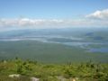
A view of Flagstaff from the Bigelow mountains


Map
|
<googlemap version="0.9" lat="45.192684" lon="-70.30838" type="terrain" zoom="11" width="600" height="350" scale="yes"> (A) 45.222949, -70.201349 Long Falls Dam (B) 45.145323, -70.283409, Mount Bigelow </googlemap> |
|
The A marker marks the Long Falls Dam, a possible put-in or take-out depending on the trip. B marks Mount Bigelow, or the Bigelow Range. You can move the map around and change the type of map to a satellite image and others in the top right corner. |