Difference between revisions of "Saddleback Mountain"
From Birocapedia
Jump to navigationJump to search| Line 5: | Line 5: | ||
Image:Piazza Rock.jpg|Piazza Rock | Image:Piazza Rock.jpg|Piazza Rock | ||
</gallery> | </gallery> | ||
| + | ==External links== | ||
| + | *[http://maps.google.com/maps?t=p&q=44.936667,-70.503056&ie=UTF8&ll=44.936667,-70.503056&spn=0.177172,0.300751&z=12&iwloc=addr Saddleback Mountain on Google Maps] | ||
| + | *[http://www.peakbagger.com/peak.aspx?pid=6848 PeakBagger.com: Saddleback Mountain] | ||
| + | *[http://www.summitpost.org/mountain/rock/151047/saddleback-mountain.html summitpost.org: Saddleback Mountain] | ||
| + | *[http://geonames.usgs.gov/pls/gnispublic/f?p=gnispq:3:13359053134910072507::NO::P3_FID:574668 USGS GNIS: Saddleback Mountain] | ||
Revision as of 17:33, 18 June 2008
Saddleback Mountain is a mountain located in Franklin County, Maine. It has two main peaks, Saddleback itself and a sub peak, The Horn. There is a ridge that descends slightly between the two, giving it the profile of a saddle when viewed from afar. Saddleback's peak elevation is 2446 feet and The Horn is 4041 feet at its highest. The Appalachian Trail runs over the summit and along the ridge between the two peaks. The first campsite 1.4 miles from the trail head features Piazza Rock, a huge cantilevered boulder. This campsite also has a double outhouse with a board game in between the two toilets. Buzzard's Roost or Eagle's Nest usually does the trip to Saddleback.
Pictures
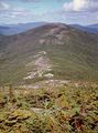
The ridge between the main peak of Saddleback and The Horn
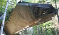
Piazza Rock

